The rain had already soaked through my trainers before the wind really got going. Not a dramatic moment. No thunderclap. Just that slow, worrying realisation that the ground underfoot felt wrong. Spongy. Tired. Like it had nothing left to give.
That’s the thing about Storm Chandra. It didn’t arrive with fireworks. It arrived on top of everything else.
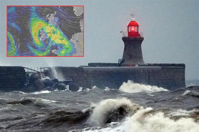
January has been a total slog. We’ve had weeks of relentless rain. Rivers were already high, and the fields were saturated with water, resembling old, sodden dishcloths. Then Chandra turned up today, Tuesday, 27 January 2026, dragging cold air from the north and a deep Atlantic low from the southwest. It mashed them together over a country that was already knackered.
By mid-morning, the Met Office warnings were stacked like overdue bills. Amber wind alerts across Northern Ireland. Amber rain warnings for parts of Devon and Cornwall. Red flood warnings—the “danger to life” kind—are currently active in places like Ottery St Mary on the River Otter. And snow. Proper snow. The kind that doesn’t melt by lunchtime.
Storm Chandra wasn’t neat. It didn’t follow the usual west-to-east script. It came in confused, sharp-edged, and awkward, finding every weak spot the UK’s infrastructure has been quietly carrying for years.
Why Chandra Caught Us Off-Guard
Most storms follow the same tired script. They batter the usual suspects—coastal Wales, the Irish Sea, the exposed western hills. People there brace for it; the councils know the drill by heart. But Storm Chandra didn’t play along.
Take Northern Ireland. Today, easterly gales slammed into the coast. That’s a direction that still catches planners off guard because it’s rare for a system this deep to hit from that side.
We’ve seen gusts hitting 75 mph across Antrim, Down, and parts of Derry. It’s a bit of a nightmare for the local ecology, too; trees that have spent decades leaning one way to survive Atlantic winds suddenly took the hit from the “wrong” side. They didn’t stand a chance. Power lines followed them down, and as of this afternoon, NIE Networks is still scrambling to get the lights back on.
It’s not just a UK problem, either. Cross the border into the Republic and you’ll see the exact same story playing out. Met Éireann didn’t mince their words today—they’ve slapped a Status There’s a yellow wind warning in every single county, and that’s staying in place right through until 11pm tonight.
Down in the southeast, places like Wexford and Waterford are getting absolutely hammered by rain on top of the wind. Honestly, it’s a mess. Whether it’s trees coming down in the middle of Dublin or the sea breaching walls on the coast, the whole island’s infrastructure is basically taking the same brutal easterly punch at once.
Further north, in Scotland and northern England, the cold air simply held its ground. It turned what could have been rain into a proper winter crisis. Snow piled up fast—I’m talking 20 centimetres in the Pennines and Highlands. Drifts swallowed single-track roads whole. Visibility dropped to basically nothing, and honestly, the gritters were fighting a losing battle by midday.
Also read: Hottest Places To Visit In January When You’ve Had Enough Of The Cold
Why the Ground Stopped Saying Yes
Here’s the thing people usually miss: flooding isn’t just about how much rain falls today. It’s about how much rain fell two weeks ago. By the time Chandra arrived, the UK’s soil was finished. Saturated to the limit.
Farmers have been sounding the alarm for weeks and watching drainage ditches fill up and fields turn into unusable marshes. When Chandra brought another 30 to 80 mm of rain, the water had nowhere to go. It wouldn’t absorb, so it just sat there, seeking an exit.
That’s why we’re seeing surface water flooding some of these roads for the first time in years. Railway cuttings have turned into canals. Urban drains are backing up. In towns across the Southwest and Northern Ireland, water is bubbling up in places nobody expected—garages, alleyways, and the low corners of car parks.
The Environment Agency has now issued over 100 flood warnings today. But the headline is the Severe Flood Warning for Ottery St Mary. It’s the only one of its kind in the country right now, and it carries a flat-out ‘Danger to Life’ tag.
The Agency is warning residents in the Finnimore Industrial Estate and Tumbling Weir Way that flood water will be deep and fast-flowing, with river levels at the Fenny Bridges gauge forecast to hit their highest level ever recorded.
Also read: Stop the Protein Panic: Natural Sources Of Proteins That Actually Fit Real Life
Power Cuts and Daily Chaos
Storm coverage always obsesses over the cinematic moments—the fallen oak or the RNLI rescue. But most of Chandra’s damage is happening off-camera.
- In North Yorkshire: Scattered power cuts all morning. Engineers have been out since first light in freezing conditions, trying to restore supply to villages where the winter dark feels a lot heavier.
- In the South West: School transport is a mess. Flooded roads in Devon and Somerset meant buses were rerouted or cancelled. It’s a “no-notice” juggling act for parents.
- In Northern Ireland: They aren’t taking chances. At least 240 schools have stayed shut today due to the winds.
- On the Rails: National Rail warned that South Western Railway services would be hit by “poor weather” all day.
The UK’s infrastructure didn’t exactly collapse today. It just bent. But as anyone sitting in a cold house will tell you, bending still costs you time, money, and a decent night’s sleep.
The Chandra Survival Guide: Don’t Be a Statistic
Look, we all think we’re better drivers than we actually are, but Storm Chandra is proving to be a different beast. Here’s the no-nonsense list of what you actually need to do while this system is sitting on top of us today.
- Respect the “Sponge” Effect: The ground is finished. It’s sodden. If you see a puddle on a backroad in Devon or Antrim that looks ‘fine’, don’t risk it. According to Environment Agency safety guidelines, it only takes about 30cm of moving water to turn your car into a very expensive, floating disaster.
- The Power Issue: With these easterly gales, those quiet power cuts in North Yorkshire aren’t just a glitch. Charge your power banks now. If the lights go out, stick to torches. The last thing the fire service needs today is a house fire started by a tipped-over candle.
- Stay Off the Ladders: Those 75 mph gusts are hitting buildings from the “wrong” side. If you’ve got loose tiles or a rattling fence, just leave it. Trying to fix a roof in this wind is a proper recipe for a hospital visit. It can wait until Thursday.
- Check the Neighbours: Honestly, just a quick text or a knock on the door for the older folks on your street makes a massive difference. If their heating has tripped or they’re just spooked by the wind, they might not want to bother anyone. Be the person who bothers them anyway.
Also read: Swicy, Salty, and Strongly Brewed: The Brave New World of Thai Tea
The Fragility of the “New Normal”
As the winds ease later tonight and into Wednesday, 28 January, the headlines will shift toward the cost of the clean-up. But the bigger question is: how much slack is left?
We’re seeing a pattern where it doesn’t take a “once-in-a-century” event to break things. It just takes two or three medium storms like Goretti and Chandra hitting in quick succession. It’s not that our infrastructure is failing by any means, but it was built for conditions it was not designed to be used under.
Storm Chandra will pass, the snow melt and the rivers will fall back. But until we begin to regard the Saturation Point as a new baseline for British winters, we’re simply waiting for the next name on the list to find the next crack in the wall.
Honestly, it’s a lot to sit with. Stay safe out there.
Sources and References
- Met Office: Storm Chandra has been named – official warnings and track
- Environment Agency: Severe flood warning for River Otter at Ottery St. Mary (Danger to Life)
- Met Éireann: Nationwide Status Yellow wind and rain alerts for Ireland
- The Guardian: Storm Chandra: Severe flooding and red warnings in Devon
- Belfast Live: Live updates: 300+ school closures and 75mph gales in Northern Ireland
- Irish Mirror: Nationwide upgrades: Storm Chandra travel chaos across the Republic